
Although Botswana has the potential to be a great hiking destination, there are very few recognised hiking paths or marked trails. That’s not to say there are no hiking places – you just need to have an adventurous streak and to be prepared to blaze your own trail! The Botswana Tourism Organisation highlights that the hills in the south east of the country are good hiking options. However, they caution that “the bush is harsh with many acacia thorn trees and other prickly scrub”. They recommend long sleeves, gardening gloves, a pair of gardening clippers and some form of GPS to guide you. So armed with garden clippers, Ditiro and I set off for Otse Hill.

At 1,491 metres, Otse Hill is widely considered to be Botswana’s highest peak though some argue that nearby Mannyelanong may be slightly taller. When looking for information on Otse Hill, I stumbled on a blog by two American travellers who climbed both hills over a weekend in 2015 and found that Mannyelanong was 10m shorter than Otse. I also found a blog from a British climber who visited Botswana for the sole purpose of climbing its highest peak! With the hill just a 45 minute drive from Gaborone, we thought it was about time we tackled this hill.
“To touch the sky, you just have to get that little bit closer.” –
We anticipated at least 3 hours of hiking so we left the kids with my dad. As we headed out, we weren’t sure what Otse Hill looked like and although we had read the blogs I mentioned earlier, we didn’t pay attention to the finer details, something we would soon regret! On the road to Otse Police College we saw an open gate with a dirt road to our left which looked like it was headed in the right direction. After a bumpy ride we got to a sign pointing towards the old Manganese Mines. Shortly after this, there was a left turn with the sign Segorong Gorge which I remembered was mentioned in one of the blogs. We took this turn and then passed the distinctive and infamous hill, Lentswe La Baratani, literally translated as the “Hill of Lovers”. The name comes from the story of two young lovers from Otse who climbed the hill and disappeared after being told they couldn’t marry. One version of the legend says they committed suicide by throwing themselves off the cliff and another version states they hid in a sacred part of the hill never to be seen again. Climbing this hill is strictly forbidden but we stopped for a quick photo.


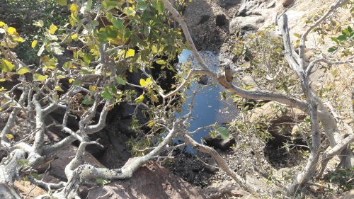
Soon after, we reached the Segorong Gorge sign and parked. We set off through a dry river bed filled with rocks and boulders which eventually became the gorge. The gorge meandered around the beautiful sedimentary rocks of the Otse Hills and is the highest gorge in the country.

We were surrounded by many moselesele trees, the odd mogonono and the occasional fig tree with spectacular roots embedded in the rocks. The vegetation became more dense with trees lining our path quite beautifully and dominated largely by moologa which has a distinct peppermint scent. There were mohudiri trees and various other Combretum species. The earth was dark brown to red often littered with dry brown leaves which sometimes concealed holes as I discovered a couple of times. There were some great rocky outcrops and also some caves with remnants of fire likely from religious ceremonies. We also saw a few bovine bones.


The path started off fairly obvious but once we had entered the gorge it was pretty much non-existent. We followed the gorge, zig zagging through it to avoid some of the steeper sections. We didn’t see any hills at this point as we were surrounded by so much bush so we weren’t sure whether to keep going or to make a decision to leave the gorge. We got to a point where there was a clear hill on our right but on Google Maps, the Otse Hill Peak was shown to our left. Ditiro looked at the contour lines of the map and noticed that the one on our right had one more contour. But Google and another topography app we had both said left. So we went left.


With no actual path, we had to make our way through long prickly grass, oftentimes loose rocks (many of which had been overturned by baboons hunting for scorpions), always bearing in mind that snakes were coming out from hibernation with the warmer temperatures. There was also a lot of scrambling up and down boulders and slippery rockfaces. As we battled the terrain and hot sun, we kept looking back and the hill on the right always looked significantly taller than where we were heading. Ditiro consoled us by saying we would soon see a difference.

We finally got to the top, looked at Google Maps to find that we had arrived at the peak. But there was no beacon. We walked around holding the mobile phone and watched as it told us we had zero metres left. We were here. But we were not! Where was the beacon?! Then Ditiro with his sharp eye spotted a beacon on another hill in the distance. It looked far but we had come too close to give up now. So off we went, now walking through chest-high grass with barbed seeds, chasing the beacon. Vultures circled in the distance and with the blue skies and the hilly terrain, it was a magnificent sight. But we were exhausted. At one point, I cried. We had gone through most of our snacks and I told Ditiro, “I’m not built for this. I’m not having fun.” But at last, three hours into our hike, we got to the beacon. It read Otse East. This was NOT the highest peak.


We glanced at the hill next to this one which looked taller and thought maybe there is a beacon up there. So we walked across only to find a fenced area with large concrete blocks which looked like they were for anchoring some telecoms masts. As we approached, a rock dassie darted away and then a pair of bushbuck sprung behind the structure and down the other side of the hill. But no beacon. We called it. We were done. We sat on a rock, ate our last snack bar and responded to my dad’s message, “Are you back from Otse Hill?” We replied, “We are still hunting for a beacon.” We were so disappointed and Ditiro in a huff said we should NOT walk back to Google peak and instead pointed in the direction he thought our car was, stating, “Since we made it here on no actual path, we might as well make another path.” So we set off like pioneers, bush-bashing through scratchy shrubs which lined our socks with prickly grass seeds.


I’m not a very superstitious person but with Lentswe La Baratani always in our sight to the right, I felt nervous and thought if ever two lovers were to disappear again, this would be the year it would happen! There were very eerie gusts of wind causing the leaves to rustle very loudly.


We heard barking baboons and a herd of kudu would occasionally bolt through the bushes. We also saw hyena droppings. At this point, we had run out of water. Eventually we found a gorge that Ditiro presumed would meet the gorge we had started on. There were a few treacherous drops that we had to work our way around. But eventually we found the original gorge (with our faded footprints from that morning) and knew we were soon done. As a final farewell to us, we saw a troop of baboons casually crossing the path ahead. After 5.5 hours, we emerged from the dry riverbed – exhausted, thirsty, hungry, sun-burnt. What an unexpected adventure!
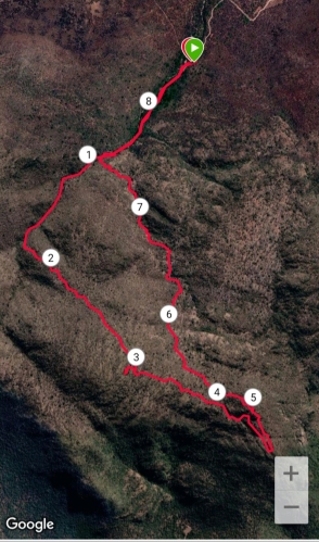

Once we had loaded up our stats, we saw we had climbed 20 metres lower than the 1,491 metres and when we re-read one climber’s blog – we realised that the hill Ditiro had pointed out to our right was THE hill we should have gone up after all. Google had it wrong and we should have gone with Ditiro’s map reading skills from Mr Walker’s High School Geography class! So my friends, we didn’t get to the highest peak but what a great adventure we had. I’m proud that we persisted, climbing peak after peak in search of THE one. We didn’t get there this time but this just means the search for Botswana’s highest peak continues!
Have you ever had a hike that didn’t go according to plan? Has Google Maps ever led you astray? Have you climbed the highest peak in your area or country?
I’m joining two amazing runners, Kim from Running on the Fly and Deborah from Confessions from a Mother Runner for their link up, the “Weekly Run Down”. Hop on over to their blogs and others, and be inspired!

Ha, my trail run today didn’t go according to plan when I took a turn onto a new trail that didn’t lead anywhere good but into a ditch along the road. Ugh. Your hike looks fun even though you didn’t get to your ultimate destination! The journey is really the fun part anyways!
LikeLiked by 1 person
I was so disappointed! But Ditiro and I have not stopped laughing today 🤣🤣 And as he says, had we just gotten to our destination the story wouldn’t have been half as good 🤣 Sorry about your trail drama!
LikeLike
I know you didn’t arrive at the planned destination, but it seems like all the fun was during the hike itself!
LikeLiked by 1 person
At some point during the hike (actually a few times), I questioned why we were there. But looking back I realise what fun we had and how much we have to laugh about. We will find that summit!
LikeLike
Wow looks like quite an adventure and a really fun and challenging way to spend the day!
LikeLiked by 1 person
It certainly was an adventure and although there were moments I felt so discouraged during the hike, I am so glad we spent the day that way! Got home and chilled after that!
LikeLike
Wow, you are way more adventurous than I am! I can’t imagine going on a hike that requires hedge clippers! Bummer that you didn’t reach the peak you were looking for, but OF COURSE that just means you get to plan for another adventure!
LikeLiked by 1 person
I’m not sure why I keep doing this to myself! LOL. But we had such fun. And yes, we WILL definitely get out there again for Part 2!
LikeLike
I loved following along with you on your climb. Thanks for sharing it with us!
LikeLiked by 1 person
Haha, glad you enjoyed this little adventure!
LikeLike
So glad you’re OK — but I really enjoyed this. The arched tree is awesome and I bet the smell of peppermint was somewhat refreshing. I thik I’d have freaked out about baboons, and hyenas. Further proof we need to do that “this is where I run” prompt.
My brother and sister in law did a half near one of NY’s tallest mountains – but NY doesn’t have much in the way of height either. 5344 feet or 1629 meters so not much taller than yours. Hope you’re able to do Otse soon. And yes, offline maps sometimes better than GPS. Phone compasses seem the worst
LikeLiked by 1 person
So glad you enjoyed this and aside from a slightly bruised ego, I’m 100% okay! Actually, once I came to terms with the fact that we didn’t get to the actual summit, I looked back and thought what fun we had even in some of those low moments. We actually said we need to do this more often!
LikeLike
and the memories much stronger than “We went up, we came back down”. Know they weren’t with you, but great story too for the kids
LikeLiked by 1 person
So true! 🤣🤣 It was a very good bedtime story for them!
LikeLike
And the search for the highest peak continues!
Well done, Shathiso! That was an awesome hike. I think I would have cried too!
I had to laugh because with that legend of the Hill of Lovers I would have thought the same – just the right year for another couple to disappear into thin air, LOL!
Well done and looking forward to the next attempt.
LikeLiked by 1 person
If it was going to happen in any year, 2020 was it! 🤣🤣 I love a good cry to release all the tension but luckily once I’m done, I carry on. Ditiro used to panic in our early days together. Now he knows the drill!! 🤣🤣
LikeLiked by 1 person
The landscape is similar to the dry harsh lands here in Australia. Reminds me of our hikes here.
LikeLiked by 1 person
My husband studied in Western Australia and has always said there are similarities to here. We actually did the Bibbulmun Track starting in Perth for about 7 days – 20km each day! That was intense but I appreciated there was an actual path to follow!!
LikeLike
Oh wow that’s amazing! You’ve done more of the Bibbulmun than me! Lol. Well I do a lot of day hikes on it but I am dreaming of doing multi day like you did! The Bibb is very green at the moment with all the rain we’ve had, probably more greener than Botswana! Cheers!
LikeLiked by 1 person
We loved it – it was in 2005 and we weren’t married then, but we always said if we could survive Bibb together, we could survive anything. There were many tears but lots of laughs too. I would highly recommend doing a multi-day hike BUT pack less than us. We were so inexperienced and carried lots of canned food that just weighed us down. LOL.
LikeLike
Ah, how wonderful! Love it! But I agree with Coco, now you will have to go back!
LikeLiked by 1 person
Most definitely!!!! And this time we will find THAT beacon! LOL!
LikeLike
Oh wow! So happy the story has a happy ending. I can tell you right now, we would have turned around long before you did. I remember one hike we did in Idaho, where it looked like we had to cross a stream . . . nope, we turned around!
The beginning looks lovely anyway. 🙂
LikeLiked by 1 person
I suspect had we been faced with crossing a stream I too would have turned back my friend! I can do most things but water, stream crossings, squishy shoes and wet clothes — no!! LOL.
LikeLiked by 1 person
What an adventure! Kudos to the both of you. I would have cried too from being hungry and tired. How is it that I can run for 5 hours but yet mostly likely will not do a hike like this? Baboons and hyena droppings? No thanks. 🙂
So the million dollar question now is, are you planning to go back?
LikeLiked by 1 person
🤣🤣🤣 Thank you! And the answer to the million dollar question is YES!! And this time with the correct beacon shot! 🤣
LikeLiked by 1 person
You said the correct answer!!
LikeLiked by 1 person
What an incredible hike! Love the photos. I have the same camelbak as you!
LikeLiked by 1 person
Thank you Jessie!! I love this camelbak! Sits very comfortably 😁
LikeLike
Wow, what an adventure! I’m sorry you didn’t find the right peak but you sure did accomplish alot! I can’t imagine being out hiking for that long!
LikeLiked by 1 person
Thank you Lisa! A few tears and frustrations along the way but in hindsight such a great adventure!
LikeLike
Wow it never occurred to me to bring garden clippers along on a hike! That hike was quite the adventure and it looks beautiful, although I’m sure it was frustrating at times.
LikeLiked by 1 person
Frustrating but really worth it! And at least we know where we went wrong and what to do next time… I hope!
LikeLike
Wow, that was quite an adventure! Glad you both made it back safely 🙂 And you got some beautiful photos out of it.
LikeLiked by 1 person
Thank you! So glad we were able to capture the day in photos!
LikeLike
Oh goodness, well done you, not one I would have done!
We went for a walk in the Lake District one time and I think we had a photocopied guide thing and I can read a map pretty well but I mistook where we started and we went in a stupid circle and got lost and only had a hot cross bun and one bottle of water with us and I cried for our stupidity. Then we realised we’d gone in a circle and it was fine. Ha!
LikeLiked by 1 person
Haha!!! Glad we’re not the only ones with some hiking mishaps! Thanks for sharing that story 🤣
LikeLike
Oh, how amazing! You have some of the most beautiful hiking spots and views ❤
LikeLiked by 1 person
I’ve loved exploring these areas – so glad I put this hiking challenge on my 40 By 40 List!
LikeLike
Why yes… Google puts my own house at the wrong end of our street. So I’ve never completely trusted it!
LikeLiked by 1 person
Haha! I will never trust it again – and if I hadn’t seen photos of the actual beacon at the top of the hill, I would have wrongly assumed we had made it to the top, LOL!
LikeLike
Now that’s an adventure!! You’re lucky you didn’t experience any wildlife considering how long you were out there (snakes? hyenas? Eek!!!!). What a great story!
LikeLiked by 1 person
Such an unexpected adventure. I thought it would be a lot simpler! And those animals were probably somewhere lurking and watching! 🤣
LikeLike
Oh man, what an adventure. It sounds like you had a good time though 🙂
LikeLiked by 1 person
Wasn’t the adventure I expected, but so glad we did it! And we have an excuse to visit again and this time find the right place.
LikeLike
Next time you’ll find it for sure!
LikeLiked by 1 person
When you know better, you do better! 🤣🤣 So yes!!
LikeLiked by 1 person
But you didn’t get to use the clippers?? Oh man! Love this story. Despite not finding your spot, it does sound like a great adventure!
LikeLiked by 1 person
Funny thing, we left the clippers in the car BUT in hindsight they actually would have come in really handy 🤣
LikeLiked by 1 person